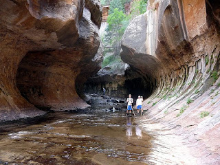
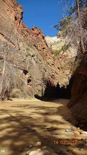
We visited Zion National Park
as part of our week-long vacation. It is one of the ultimate destinations for
avid hikers and mountaineers.
Zion National Park is located
near Springdale, Utah in the Southwestern United States. Zion Canyon, which is
15 miles long and up to half a mile deep is located in the 229-square-mile Zion
National Park and cuts through the reddish and tan-colored Navajo Sandstone by
the Northfork of the Virgin River. The highest elevation in the Park is 8726
ft. The Park is home to numerous plant species as well as birds, mammals and reptiles
and has 4 distinct life-zones: desert, riparian, woodland and coniferous
forest. It is reported that human habitation in this area started almost 8000
years ago, with small family groups of Native Americans. To protect the Canyon,
in 1909, the President of the US declared the area a National Monument, under
the name of Mukuntuweap National Monument, which however got changed into Zion
National Park subsequently, a name used by the local Mormon clan, to make it
more attractive to tourists.
“It’s ironic, in
this seemingly unending desert, that water creates most of what we see. North
of Zion, rain falling on the 11000-foot-high Colorado Plateau races downhill,
slices Zion’s relatively soft layers, and pushes it debris off the Plateau’s
southern edge. This edge is not abrupt, but it steps down in a series of cliffs
and slopes down as the Grand Staircase. Above Zion, topping the Staircase,
Bryce Canyon’s crenellated edges form as water trickles off the Plateau. Below
Zion, Grand Canyon forms the lowest rung into which 90 percent of Colorado
Plateau waters run. Zion’s gathered waters, known as the Virgin River, traverse
Mojave Desert lands and join the Colorado River in the Lake Mead’s handmade
basin before completing their Pacific-bound journey.”- From the brochure at Zion National Park.
The Zion and the adjacent Kolob Canyons are marked by 9
varieties of rock formations, formed over 150 million years of sedimentation. These rock units are called the Grand Staircase.
Here are the pictures of the different
formations of rocks.
 |
| Dakota Sandstone formation |
 |
| Carmel Formation |
 |
| Temple Cap Formation |
 |
| Navajo Sandstone formation |
 |
| Keyenta Formation |
 |
| Moenave Formation |
 |
| Chinle Formation |
 |
| Moenkopi formation |
 |
| Hurricane Cliffs |
The 6-mile long road into the Zion
Canyon ends at the Temple of Sinawava, referring to the Coyote God of Paiute
Indians. The canyon narrows at the Temple. There is a kilometer-long foot-trail
to the mouth of the canyon narrows, along the Virgin River. From there, one has
to go through a 20-feet narrow gorge up 2000 feet to reach the top. The Zion
Narrows through the river was closed when we visited. It is reported to be a hazardous and
uncertain trek with the upstream Virgin River water stream.
The Zion National Park is served by a
free shuttle service between April and October of a year, starting from the
Visitor Centre all the way up to the Sinawava Temple stopping over 9 points
along the way for the benefit of the hikers and tourists. The other roads of
the Zion are open to all private vehicles year-round.
While moving around in the shuttle we
could also see a few mountaineers climbing up the steep rocks using ropes and
hooks and a few others having overnight rest on a hammock suspended from
vertical rocks.
There are different trails, some easy,
some moderate, and some really steep and hard. We did the easier one along the
river from the Grotto as well as the paved Riverside Walk from the Sinawava
Temple. Angels Landing Trail, a 5.4 miles trail with long drop-offs, the last
section of which is a route along a steep, narrow ridge to the summit, often
covered by snow and ice is said to be one of the most strenuous ones. In a separate blog, I am
attaching a video on the Angels Landing Trail that I saw on the YouTube. Hair
raising, butterfly-in-the stomach trail, really!
We also drove through the Zion-Mount
Carmel scenic Highway, passing through the Carmel Tunnel. On the way we saw the
notable Checkerboard Mesa and the East Temple. On our return, some of us went
up a steep hike on the Canyon Overlook Trail, just before the Tunnel.
Kolob Arch, the world’s second longest natural arch lies on the adjacent
Kolob Canyon section. However, due to want of time, we couldn’t visit Kolob
Canyon.
The weather in Zion Canyon changes with the seasons. The
Spring and Autumn seem to be the most acceptable season to visit the Canyon.
Summer could be harsh with scotching Sun and winter could mar the hikers’
enthusiasm with snowfall and ice. Storms during July through September may
produce waterfalls as well as flash floods.
The area had been inhabited by ancient
Native Americans in the past. European exploration of the Canyon had begun only
during the 18th century. Mormons had settled in the Utah areas for
their mineral deposits, timber, and for grazing cattle, sheep, and horses. They
had also diverted Kolob water to irrigate crops in the valley below. The Mormon
settlers had named the area Kolob – to mean ‘heavenly place nearest the
residence of God.’
USA does a lot to preserve Nature by
declaring a number of places as National Park. Small children are encouraged to
attempt a small test to get recognized as Junior Forest Rangers, and they are
presented with a medallion. The infrastructure like roads, electricity, parking
areas, restrooms, dining areas for picnics, ‘ramadas,’ and camping and resting areas
in these National Parks are extremely good, though cell phone tower coverage is
mostly not available inside the Canyon area due to elevation. Hikers will have
to carry their own snacks, lunch and water, wherever they go inside the Canyon.
No restaurants are available excepting at Zion Lodge Point in the middle. There
are several hotels, restaurants, lodges, shops just before the entrance to the
National Park.
Here are the pictures I took:
....Await my final report on Bryce Canyon
Please send your comments using the Comments Box.


No comments:
Post a Comment